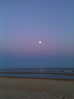
PRAIA DA MANTA ROTA
Esta é uma extensa praia associada à povoação da Manta Rota, que ainda mantém algum
do seu carácter original de terra piscatória, embora seja actualmente um
importante centro turístico. O areal delimita o sistema lagunar da Ria Formosa a
nascente. O cordão dunar é largo, especialmente a nascente e a poente da
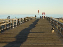
povoação, já que no centro dominam os equipamentos turísticos. Passadiços
sobrelevados levam o visitante até ao areal, Uma linha refrescante de choupos
marca o parque de estacionamento nascente desta praia. Menos frequentada que a
vizinha zona balnear de Monte Gordo, oferece ainda recantos tranquilos sobretudo
nos extremos do areal.
Apoios e infra-estruturas: Estacionamento muito amplo e ordenado. Diversos equipamentos de apoio (restaurantes e WC) e vigilância durante a época balnear, Praia Acessível.
Esta é uma extensa praia associada à povoação da Manta Rota, que ainda mantém algum
do seu carácter original de terra piscatória, embora seja actualmente um
importante centro turístico. O areal delimita o sistema lagunar da Ria Formosa a
nascente. O cordão dunar é largo, especialmente a nascente e a poente da
povoação, já que no centro dominam os equipamentos turísticos. Passadiços
sobrelevados levam o visitante até ao areal, Uma linha refrescante de choupos
marca o parque de estacionamento nascente desta praia. Menos frequentada que a
vizinha zona balnear de Monte Gordo, oferece ainda recantos tranquilos sobretudo
nos extremos do areal.
Apoios e infra-estruturas: Estacionamento muito amplo e ordenado. Diversos equipamentos de apoio (restaurantes e WC) e vigilância durante a época balnear, Praia Acessível.
PRAIA DA MANTA ROTA
Praia da Manta Rota is an extensive beach associated with the
village of Manta Rota , that still maintains some of its original character as a
fishing village, although today it is an important touristic center.
The sand dunes to the west limits the lagoon system of the Ria Formosa.
The dunes are wide, specially west and east of the village, whereas in the
middle the touristic equipments are abundant. Elevated boardwalks take the
visitor to the sand. A refreshing line of poplars mark the parking lot. Not as
visited as the neighboring bathing area of Monte Gordo , it offers quiet spots
specially .
Services and infra-structures: Ample and organized parking. Various
support equipments as restaurants and toilets and life guards during bathing
season. It is an accessible beach.
PRAIA VERDE
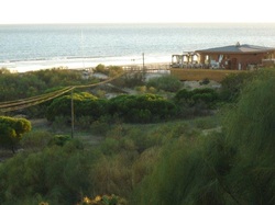
A Praia Verde é uma praia marítima do concelho de Castro Marim,
Algarve, Portugal. Fica situada entre a praia da Alagoa a poente e a praia do
Cabeço -Retur a nascente, e é abrigada por um pinhal de pinheiros mansos dos
muitos dos quais foram abatidos na zona oeste para construção de habitações .
Com água cristalina e areia branca, a praia Verde é uma das jóias do Algarve.
Conserva os vestígios de ruínas romanas junto ao mar, das quais se salienta o
poço romano.
Antigamente existia um grande parque de campismo que durou até à década de 1990.
Esta praia é vigiada pela delegação marítima, e está sinalizada, conta com o apoio de
nadadores-salvadores e posto de primeiros socorros durante a época balnear.
Como equipamentos e serviços de apoio esta praia conta com restaurantes e bar e aluguer de toldos durante a época balnear.
A qualidade da água é controlada mensalmente durante a época balnear.
PRAIA VERDE
The Praia Verde is a beach of the council of Castro Marim, Algarve, Portugal. It is located between the Praia da Alagoa, to the west, and Praia do Cabeço-Retur, to the east. It is sheltered by a pine forest, some of the trees ,to the west , have been replaced by private houses. With crystal clear waters and white sand Praia Verde is one of the jewels of the Algarve. It still conserves roman ruins near the sea, one of which is a roman well.
Previously there used to be a big campsite that was open until the 1990’s.
This beach is monitored by the maritime delegation, and has life guards as well as first aid station during the official bathing season. This beach also has other services including, restaurants, bars
and rental of sun loungers and covers during bathing season. The quality of the
water is controlled monthly during bathing season.
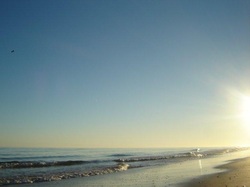
PRAIA DA LOTA
Este areal de perder de vista foi, em tempos, uma lota onde se vendia o peixe acabado
de chegar da faina no mar. Actualmente ainda se observam algumas embarcações de
pesca artesanal e as respectivas artes de pesca, mas o seu uso é essencialmente
balnear. As dunas são baixas tendo como vegetação dominante o estorno e o
felpudo cordeirinho-da-praia, típicos da frente dunar. A praia é relativamente
tranquila, muito quente e luminosa, a rebentação é suave e os banhos
mornos.
Apoios e infra-estruturas: Estacionamento ordenado, restaurantes, WC e vigilância
durante a época balnear, Praia Acessível.
PRAIA DA LOTA
Praia da Lota with its extensive sand dunes was a selling point for
the fish freshly caught at sea. Presently it is still possible to see some
artisanal fishing boats and their respective art of fishing, but its use is
fundamentally for bathing. The dunes are low with the typical vegetation for dune
fronts. The beach is relatively quiet, very hot and luminous. The waves are soft
and the water warm.
Services and infra-structures: Ample and organized parking. Various
support equipments as restaurants and toilets and life guards during bathing
season. It is an accessible beach.
ILHA DE TAVIRA
A Ilha de Tavira é uma ilha arenosa com cerca de 11 km de comprimento, localizada
junto à costa algarvia, a sul da cidade de Tavira, e faz parte do Parque Natural da Ria Formosa. As
suas praias são muito frequentadas por turistas, em especial durante a época balnear; a sua elevada qualidade ambiental é atestada anualmente pela certificação com Bandeira Azul. Os sapais e
pequenos canais da Ria Formosa adjacentes à ilha constituem óptimos locais para a observação e estudo de aves marinhas.
Como infraestruturas de apoio ao turismo a ilha dispõe de um
parque de campismo e de concessões de praia durante o período balnear. O acesso é feito através de
barcos que partem de Tavira ou do cais das Quatro Águas, ou a pé via uma ponte que se situa junto da aldeia turística Pedras D'el Rei.
A ilha possui quatro praias. De leste para oeste, encontramos em primeiro lugar a Praia da Ilha de Tavira(ou simplesmente Praia de Tavira), seguindo-se a Praia da Terra Estreita, a Praia do Barril e a Praia do Homem Nu. Nos pontos da ilha mais afastados das concessões de praia o naturismo é tolerado; contudo, na região ocidentalda Praia do Barril o naturismo encontra-se legalizado.
ISLAND OF TAVIRA
The Island of Tavira is a sandy island approximately 11kms long, located on the Algarvian coast, south of the city of Tavira, and is part of the Natural Park of Ria Formosa. Its beaches are
frequented by tourists, especially during the bathing season. Its high environmental quality is attested annually by its certification with the Blue Flag. The marshes and small canals of the Ria Formosa , adjacent to the island, constitute the ideal place to watch and study birds.
As support infra-structures for tourism the island has a campsite and various beach concessions during the bathing season. The access is made by boat that leave from Tavira or the pier at Quatro Àguas, or by foot on the bridge situated near the touristic village of Pedras D’el Rei.
The island has four beaches. From east to west you’ll find the beach of the Island of Tavira or simply beach of Tavira, then you have Beach of Terra Estreita, beach of Barril and the beach of the Homen Nu. At the furthest points from the concession naturalism is tolerated; but at the western part of beach of Barril naturalism is legalized.
